Basic Information
Basic Information
- Area
- 384.10㎢(2.0% of Gyeongsangbuk-do Province)
- Population
- 35,525 / 16,241 households (18,639 males, 16,886 females)
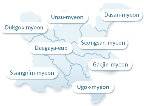
- Administrative Districts
- 1 Eup 7 Myeon (153 Ri 663 Ban)
- Administrative Organization
- 2 offices, 9 divisions, 1 department, 2 directly
controlled agencies, 3 affiliated agencies,
county council office.
- Civil Servants
- 518 (Main office: 406 employees / Eup/Myeon: 112 employees)
- County Finances
- 2018 annual budget: KRW 294.3 billion (general account: KRW 279.7 billion, special account: KRW 14.6 billion)
County Economy
- Industrial Zones
- 5 zones (3 industrial zones, 2 agricultural-industrial zones) / 1,980,000 ㎡ (600,000 pyeong)
- Companies
- 1,020 (No. of Employees: 10,247)
- Industry structure
- mining 49.2%, agriculture 12.3%, construction 9.1%, others 29.4%
- County GDP
- KRW 982 billion (2012 GRDP basis), GDP per capita: $24,359
Tourist Facilities
- Museums
- 2 (Daegaya Museum, Ureuk Museum)
- Exhibition Halls
- 1 (Wangneung Royal Tomb Exhibition Hall)
- Tourist sites
- 1 (Daegaya History Theme Park)
- Vacation Complexes
- 3 (Daegaya Arboretum, Jusan Mountain Forest Park, Misung Mountain Natural Recreation Forest)
- Experience Villages
- 6 villages (Gaesil, Gayatgo, Sanju, Seowujae, Sinri, and Ye)
- Buddhist temples
- 2 (Gwaneumsa Temple, Ballryongsa Temple)
Geography and Natural
Terrain
In the west, Mandaesan Mountain sits to the southwest of Misungsan Mountain, forming a natural boundary with Gyeongsangnam-do Province. In the east, the Nakdonggang River flows around four myeon(“townships”), forming a natural boundary with Dalsung-gun. In the north, the Uibongsan Mountain and Gayasan Mountain ranges separate the county from Seongju-gun county.
Streams
The Hoecheon and Sogacheon Streams originate in the valleys of Gayasan Mountain, and flow through Wunsu and Deokgok-myeon before converging in Bongwan-ri, Daegaya-eup. The streams then join Anrimcheon Stream (which flows through Ssangrim-myeon via Gayasan Mountain in Gyeongsangnam-do Province) in the lower southeast part of Daegaya-eup, ultimately flowing into the Nakdonggang River.
Transportation
The Gwangju Daegu Expressway bisects (19.8km in length) the county in the west-east direction. The Daegu-Gunsan, Goseong-Seonsan, Wicheon-Gimcheon and Jeokjung- Haepyeong roads run in all directions throughout the county, with Daegaya-eup at its center, making it a hub of transportation.
Administrative Districts